CSI Alps

  • Home
  • Module
    • Modul 1: Minerale/Gesteine
      • 1.1. Einführung
      • 1.2. Minerale
      • 1.3. Hauptgruppen der Gesteine
      • 1.4. Magmatische Gesteine
      • 1.5. Sedimentgesteine
      • 1.6. Metamorphe Gesteine
      • 1.7. Deformation der Gesteine
      • Gesteinssammlung
    • Modul 2: Kreislauf der Gesteine
    • Modul 3: Toolbox and forensic lab (Methodik)
    • Modul 4: Plattentektonik
    • Modul 5: Geologie der Alpen
    • Exkursionen
      • Region Bedrettotal (Bed)
      • Region Furkapass (Fur)
      • Region Glarnerland (Gla)
      • Region Hinterrhein (Hin)
      • Region Klausenpass (Kla)
      • Region Locarno (Loc)
      • Region Nufenenpass (Nuf)
      • Region Reusstal-Gotthardpass (RGo)
      • Region Sarganserland-Rheintal (Sar)
      • Region Schwyz (Swy)
      • Region Ticino (Leventina bis Bellinzona, Tic)
      • Region Zürichsee (Zür)
      • Urban Geotrail Bern
    • Schulbesuche
    • Übungen
    • Geo-Highlights der Alpen aus der Luft
  • Projekt CSI-Alps
    • Projekt CSI-Alps
    • Einführung für Lehrpersonen
    • Gesteinssammlung
    • CSI Alps als Kurzfassung
    • Der Erdwissenschaftskrimi
  • Downloads
  • Über uns
  • Links

Region Ticino (Leventina bis Bellinzona, Tic)

  • Module
  • Minerale/Gesteine (M1)
  • Kreislauf der Gesteine (M2)
  • Toolbox and forensic lab (M3)
  • Plattentektonik (M4)
  • Geologie der Alpen (M5)
  • Exkursionen
    • Region Bedrettotal (Bed)
    • Region Furkapass (Fur)
    • Region Glarnerland (Gla)
    • Region Hinterrhein (Hin)
    • Region Klausenpass (Kla)
    • Region Locarno (Loc)
    • Region Nufenenpass (Nuf)
    • Region Reusstal-Gotthardpass (RGo)
    • Region Sarganserland-Rheintal (Sar)
    • Region Schwyz (Swy)
    • Region Ticino (Leventina bis Bellinzona, Tic)
    • Region Zürichsee (Zür)
    • Urban Geotrail Bern
  • Schulbesuche
  • Übungen
  • Geo-Highlights der Alpen aus der Luft

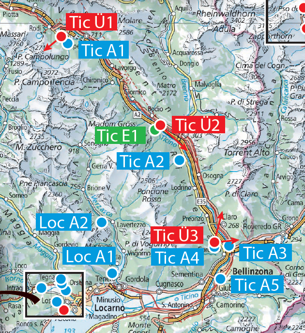
Download Region Ticino (Leventina bis Bellinzona, Tic) (zip)

Tic A1 - Dalpe / Dolomit (12)
  • Lageplan Tic Ü1, A1 (pdf)
  • Tic A1 – Dalpe (pdf)
Tic A2 - Iragna / Gneis flachliegend (14)
  • Lageplan Tic A2 (pdf)
  • Tic A2 – Iragna (pdf)
Tic A3 - Castione / Marmor, metam. Bündnerschiefer (16b)
  • Lageplan Tic Ü3, A3, A4 (pdf)
  • Tic A3 – Castione (pdf)
Tic A4 - Gnosca / Granatperidotit im Bachbett (15b)
  • Foto Granatperidotit Lageplan (pdf)
  • Tic Ü3, A3, A4 (pdf)
  • Tic A4 – Gnosca (pdf)
Tic A5 - Castel Grande Bellinzona (75)
  • Lageplan Tic A5 (pdf)
  • Tic A5 – Castel Grande Bellinzona (pdf)
Tic E1 - Biasca
  • Tic E1 – Biasca (pdf)
Tic Ü1 - Dalpe
  • Lageplan Tic Ü1, A1 (pdf)
  • Tic Ü1 – Dalpe (pdf)
Tic Ü2 - Biasca
  • Lageplan Tic Ü2, E1 (pdf)
  • Tic Ü2 – Biasca (pdf)
Tic Ü3 - Gnosca
  • Lageplan Tic Ü3, A3, A4 (pdf)
  • Tic Ü3 – Gnosca (pdf)
Fragen?
Dr. Martin Wyss: m_wyss_geo@bluewin.ch /
Prof. Jörg Hermann: joerg.hermann@geo.unibe.ch
Suche

  • www.csi-alps.unibe.ch